Bike Local: The Banks-Vernonia Trail


Friday, August 29, 2014
The Rails-to-Trails through Banks Vernonia offers scenic riding, several trestle bridges and stream crossings.
Credit: Brian Leber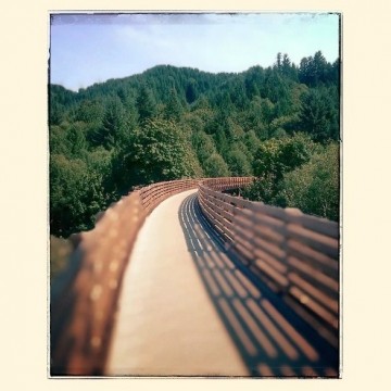
When the timber industry began to change and drop off, so did the need for railways; and the decommissioned railways resulted in miles of abandoned rail beds, waiting to be repurposed.
Just 26 miles West of Portlandia is Oregon’s first Rail-to-Trail conversion, the Banks–Vernonia Trail. The route follows a rail corridor used between the 1920s and 1957 to haul timber from mills in Vernonia into Portland. After a brief stint in the 1960s as a passenger line, the railway was decommissioned and trail construction began in 1991.
The Banks–Vernonia Rail Trail is a multi-use paved trail stretching 21 miles between Banks and Vernonia. Along the way, the trail runs through Manning, Tophill, Stub Stewart, Beaver Creek and Buxton. Providing a forested, wildflower-lined, easy grade through glades flush with wildlife, the trail provides lush, mellow recreation for cyclists, walkers, runners or equestrians.
There are 13 bridges, several streams, and two old 700-foot long, 80-foot high railroad trestles at Horseshoe and Buxton that offer spectacular views. There are some steep areas toward the top of L.L. Stub Stewart Park, if you decided to head up to the Hilltop picnic area, so take a geared bike, or plan to push your cruiser up part of the way.
Pack a lunch, your camera, and a windbreaker - it can be windy at the top, but the views are worth the effort to get there.
Parking and Trail Access
You can access the Banks-Vernonia Rail Trail in Vernonia, Beaver Creek, Tophill, Buxton, Manning and Banks. For more access details and amenities offered at each trailhead, view the Oregon State Park’s brochure and map.

Related Articles
- Bike Culture SOS: Save Our Shops
- Portland’s Bike Plan Makes Biking Safer in the City
- On Your Bike: How To Choose The Right Ride


Follow us on Pinterest Google + Facebook Twitter See It Read It