Portland Then/Now: North Interstate Ave and Shaver Street


Thursday, July 09, 2015
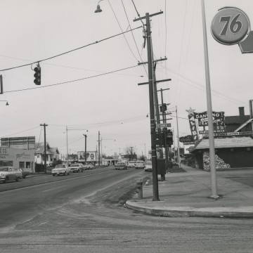
N Interstate Ave. and Shaver St., February 7, 1963: City of Portland Archives. A2005-001.336
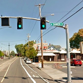
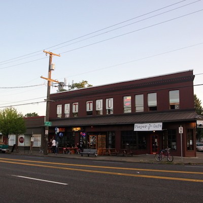
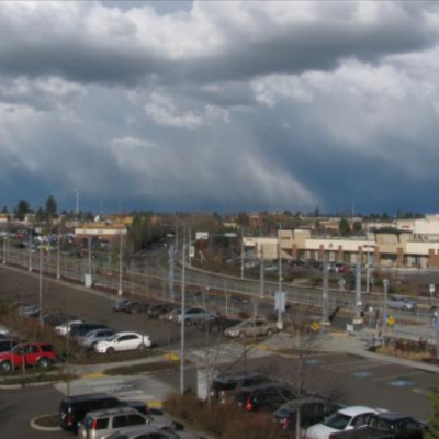
N. Interstate Ave. and Shaver St. 2015.
THEN: Here is a photo from Portland's City Archives that shows us North Interstate Avenue and Shaver Street toward the end of it's heyday in 1963. For several decades Interstate Avenue was the main arterial between Portland and points north. This avenue came to life in 1917. That's when a new bridge, called the Interstate Bridge, gave its name to two Portland arterial streets. Shortly before the bridge opened, a pair of streets through North Portland that were planned to be treated as the main route to and from the bridge, Maryland Avenue and Patton Avenue, were renamed the Interstate Highway. The highway was the main path from Portland to Vancouver prior to I-5 being built in 1964.
When Interstate-5 was built it was officially known as the EastBank Freeway, but went by the nickname of “Minnesota Freeway” (the freeway project took up the entire area where Minnesota Street once resided). Before the birth of the Eastbank Freeway, Interstate Avenue was home to various business interests, primarily restaurants and gas stations and a plethora of roadside motels that featured elaborate neon displays.
NOW: After the arrival of the nearby I-5, Interstate Avenue businesses began to disappear along with the traffic that once sailed down this thoroughfare.
It would continue like that for the next four decades until the MAX Yellow Line that runs between Portland State University and the Portland Expo Center, with most of the line running directly along North Interstate Avenue.
Since the MAX line opened up there have been several new businesses that have opened up including several restaurants. Vestiges of North Interstates former glory days as a major highway (although it is still part of Oregon Route 99W) remain with a few of the neon-hued motels and the ultra-kitschy Alibi which is home to one of Porltand’s most notable tiki rooms and karaoke lounges.
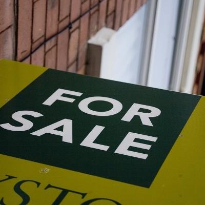
Related Slideshow: Portland’s 20 Hottest Neighborhoods for Real Estate
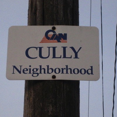
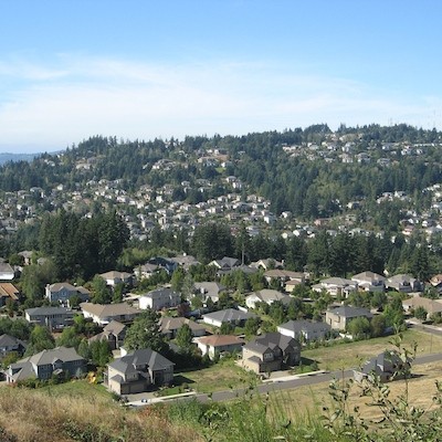
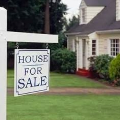
What are Portland’s hottest neighborhoods for real estate? The 20 neighborhoods below are ranked by the number of sold homes over the last 90 days. The information, along with the median list price and median price per square foot, comes from the real estate company Redfin. The population is from 2010 census data.
The sale to list percentage, also from Redfin, is the final selling price over what the listed price was, to show how close sellers came to their asking price. In cases where it is over 100 percent, the seller got more than then listed price.
Find out what the hottest real estate neighborhoods in Portland are:
_400_400_90.jpg)

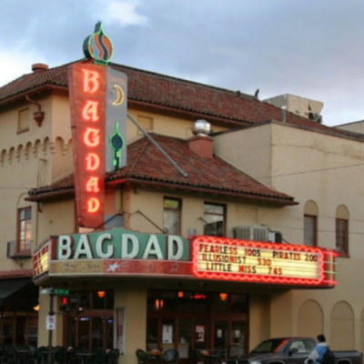
#20 (tied)
#19 (tied)
#18 (tied)
#17
#16 (tied)
#15 (tied)
#14 (tied)_80_80_90_c1.jpg)
#13 (tied)
#12 (tied)
#11 (tied)
#10
#9
#8
#7
#6
#5
#4
#3
#2
#1
Related Articles
- Portland Then/Now: Southwest Fourth Avenue and Morrison Street
- Portland Then/Now: Southwest Park Ave. and Yamhill Street
- Portland Then/Now: Southwest Park Avenue & Taylor Street
- Portland Then/Now: Southwest Second Ave. & Burnside St.
- Portland Then/Now: Southwest Fourth Avenue & Madison Street
- Portland Then/Now: Southwest Fourth Ave. & Yamhill St.
- Portland Then/Now: Southwest Broadway and Taylor Street
- Portland Then/Now: Southwest Broadway and Washington Street
- Portland Then/Now: Southwest College Street & Sixth Avenue
- Portland Then/Now: Southwest Fifth Avenue
- Portland Then/Now: Southwest Third Ave. and Burnside St.
- Portland Then/Now: SW Broadway and SW Taylor Street
- Portland Then/Now: Union Station
- Portland Then/Now: West Burnside St. and Southwest 10th Ave.
- Portland Then/Now: West Burnside St. and Southwest 18th Ave.
- Portland Then/Now: West Burnside St. and SW Vista Ave.
- Portland Then/Now: Tom McCall Waterfront Park
- Portland Then/Now: The Portland Hotel/Pioneer Courthouse Square
- Portland Then/Now: SW Park Ave. & Yamhill & Taylor St.
- Portland Then/Now: SW Washington St. & Downtown Waterfront
- Portland Then/Now: The Corner of Southwest 11th Avenue & Morrison Street
- Portland Then/Now: Southwest Broadway and Morrison Street
- Portland Then/Now: Southwest Broadway and Alder Street
- Portland Then/Now: Multnomah County Central Library
- Portland Then/Now: North Lombard St. and Portsmouth Ave.
- Portland Then/Now: Northwest 12th Avenue and Lovejoy Street
- Portland Then/Now: Northwest Broadway and Everett Street
- Portland Then/Now: Mill Ends Park
- Portland Then/Now: Hawthorne Bridge
- Portland Then/Now: Broadway and North Larabee St.
- Portland Then/Now: Downtown Portland’s Keller Fountain Park
- Portland Then/Now: East Burnside and 8th Avenue
- Portland Then/Now: Northwest Couch Street and Third Avenue
- Portland Then/Now: NW Couch St. & Second Ave.
- Portland Then/Now: South End of Burnside Bridge
- Portland Then/Now: Southwest 10th Ave. and Yamhill Street
- Portland Then/Now: Southwest 11th Ave. and Morrison St.
- Portland Then/Now: Southwest 2nd Ave. and Yamhill Street
- Portland Then/Now: SE 82nd Ave. Between Clinton & Division
- Portland Then/Now: Sandy Blvd. & Northeast 24th Ave.
- Portland Then/Now: Pioneer Courthouse Square
- Portland Then/Now: Portland City Hall
- Portland Then/Now: Portland State University & SW Park Ave.
- Portland Then/Now: Northwest Broadway Near Union Station


 Delivered Free Every
Follow us on Pinterest Google + Facebook Twitter See It Read It