VIDEO: 7.1 Earthquake Hits Southern California


Saturday, July 06, 2019
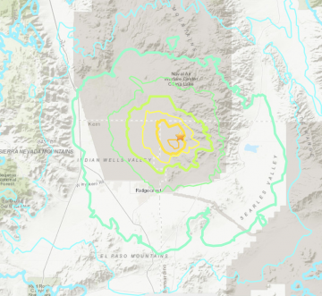
IMAGE: USGS
There are hundreds of measured aftershocks. It is the strongest quake to hit the region in the past 20 years.
The latest earthquake which hit Friday night struck 11 miles northeast of Ridgecrest, according to the US Geological Survey.
The quake was 10 times stronger than Thursday's 6.4 magnitude earthquake, also centered near Ridgecrest, a seismologist said.
"A magnitude 7.1 earthquake struck southern California on July 5, 2019 at 8:20 pm local time (03:20 UTC). This event was centered near the July 4, 2019 M6.4 earthquake," USGS posted early Saturday morning.
"USGS has issued a red alert for economic losses meaning that extensive damage is probable, and the disaster is likely widespread. Estimated economic losses are at least $1 billion dollars, less than 1% of GDP of the United States. Past events with this alert level have required a national or international level response. There is a green alert for shaking-related fatalities with a low likelihood of casualties. The closest large population center is Ridgecrest, population 28,000. Strong to very strong shaking and damage has been reported there," reported the agency.
According to CNN, "In Ridgecrest, multiple fires broke out Friday and injuries were reported, according to Kern County spokeswoman Megan Person. The county has activated an emergency operations center, and nearly 2,000 people are without power, officials said.
The San Bernardino County Fire Department said it received multiple reports of damage as well from northwest communities."
Office of the Governor of CaliforniaVerified account @CAgovernor
“In response to another large earthquake in Southern California tonight, I have activated the @Cal_OES state operation center to its highest level, and the state is coordinating mutual aid to local first responders.” - Governor @GavinNewsom
USGS Earthquake Hazards Program
The USGS role in NEHRP is to provide Earth sciences information and products for earthquake loss reduction. The goals of the USGS' Earthquake Hazards Program are:
Improve earthquake hazard identification and risk assessment methods and their use;
Maintain and improve comprehensive earthquake monitoring in the United States with focus on "real-time" systems in urban areas;
Improve the understanding of earthquakes occurrence and their effects and consequences.
UPDATED 7/6/19 at 4:47 AM.
Related Articles
- Pacific NW Fault Goes Silent, Maybe Be Indicator of Major Earthquake
- Timbers v. Earthquakes: Three Things We Learned
- Timbers vs. San Jose Earthquakes: Three Things To Watch
- Who Deserves The Captain’s Armband: Timbers v. Earthquakes
- UPDATED: Nine Earthquakes Shake Southern Oregon Border
- Oregon Celebrates Cascade Subduction Zone Earthquake Anniversary
- Magnitude 9.0+ Earthquake Headed for Oregon?
- Cascadia Rising Earthquake & Response Exercise Set for June 7-10
- The California Political Earthquake? - Sunday Political Brunch - June 10, 2018
- Portland Timbers vs. San Jose Earthquakes: Match Preview
- 4 Earthquakes Strike off Oregon Coast
- Central Italy Earthquake Kills At Least 38 People
- Could An Earthquake Threaten Portland’s Growing Pearl District?
- Magnitude 2.7 Earthquake Hits West of Vancouver, Wash.
- Half A Million People to Participate in Earthquake Drill on Thursday


Follow us on Pinterest Google + Facebook Twitter See It Read It